FAA Серьезно относится к Авиационному радиовещанию
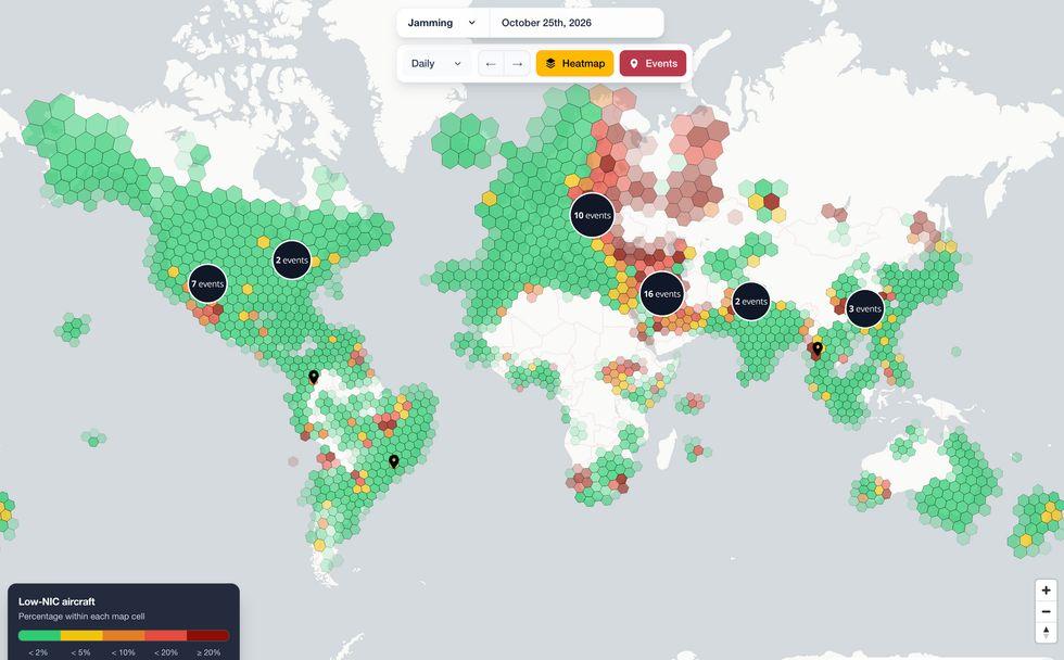
Небо становится опасно переполненным: не самолетами, а помехами и глушилками, нарушающими работу многих из 30 000 радиочастот, на которые опирается гражданская авиация. В предыдущие десятилетия разработчики авиационных метеорологических систем, систем навигации и голосовой связи ставили удобство превыше безопасности, в результате чего современные самолеты были уязвимы как для невольных помех, так и для злонамеренных помех и подмены информации, особенно вблизи зон конфликтов.
В связи с растущими угрозами и критическим отчетом Счетной палаты правительства США Федеральное управление гражданской авиации (FAA) в настоящее время разрабатывает масштабные системы мониторинга и обнаружения для защиты своего спектра по всей стране.
На дне взаимодействия с отраслью в середине октября вице-президент FAA по техническим операциям Дэн Мерфи рассказал о проблеме: "Прямо сейчас где-то в Национальной системе воздушного пространства сигнал, от которого зависит авиация, глушится, подделывается или просто ухудшается из-за чего-то еще, происходящего в системе. весь спектр."
Если это повлияет на воздушное движение, FAA начнет поиск источника, процесс, который может занять от нескольких дней до месяца и более. В случае прерывистых сигналов виновник может так и не быть найден. "Эта модель больше не работает для нас", - сказал Мерфи. "Он был разработан для более спокойного мира в авиационном спектре, которого больше не существует. Мы должны быть в состоянии найти источник помех в спектре за секунды или минуты, а не за дни или недели".
Начало полетаХотя некоторые мероприятия дня индустрии были засекречены, список участников позволяет предположить, какие технологии может рассмотреть FAA. Предлагаемые технологии могут позволить FAA обнаруживать, анализировать и определять местоположение радиопомех в беспрецедентных географических масштабах и с беспрецедентной скоростью.
Агентство уже использует данные, полученные самолетами в полете. Подавляющее большинство летающих самолетов сегодня должны использовать транспондер ADS-B, систему безопасности, которая примерно каждую секунду передает их идентификатор и местоположение. Находящиеся поблизости самолеты и наземные станции могут получать эти данные и использовать их для предотвращения столкновений.
На графике уровня сигнала глобального навигационного спутника показаны сигналы с помехами.ESA
Среди этих данных есть сигнал, который отражает уверенность GPS-приемника самолета в своем местоположении: большое значение означает, что он принимает хороший сигнал GPS, меньшее значение может свидетельствовать о помехах. Несколько организаций, включая Стэнфордский университет, собирают данные ADS-B с тысяч самолетов, чтобы строить полезные графики почти в режиме реального времениmaps of interference events.
But ADS-B surveillance has its limitations, says Todd Humphreys, director of the Radionavigation Laboratory at the University of Texas at Austin: "The data remain quite noisy, because you’re dealing with different receiver platforms and different aircraft. You need a lot of traffic through an area to be confident about interference, and of course you don’t have coverage over areas where there aren’t any flights."
Listening from spaceOne solution is to get a wider view of the problem, from space. Several commercial operators of low earth orbit (LEO) spacecraft, including HawkEye 360 and Spire Global are already listening to vast swathes of the radio spectrum.
Spire Global tracks navigation data accuracy for aviation purposes.Spire Global
For aviation customers, Spire can use ADS-B data to identify a zone of possible jamming, then task a pair of geolocation satellites to the area. Two satellites simultaneously record the same stretch of spectrum, relying on differences in the signals’ arrival times and Doppler shifts to estimate a transmitter’s location.
"In a recent analysis of recordings, we estimated the location of GPS jammers from a single satellite pass," says Bryan Cuthbertson, Spire’s senior manager for Space Reconnaissance. Spire is also working on a European Space Agency (ESA) project called Eurialo, that uses ADS-B and other aircraft transmissions to precisely locate aircraft independent of GPS and ground-based radar. Like Spire’s jamming detection, it relies on the time difference of arrival of signals. "Satellite plus ADS-B seems a pretty compelling combination," says Humphreys. However, there are not enough radio frequency-capturing satellites today to provide continuous coverage and geolocation across the entire U.S. The FAA would either have to accept delays as satellites visit different parts of the country in turn, or wait or pay for companies to launch more.
Ground truthAnother approach is to leverage assets already in place on the surface. Most modern cellphone towers have one or more GPS receivers, which collect timing signals to synchronize transmissions, as well as navigation data to boost location accuracy in cellphones in their service area. Just like the receivers in aircraft, those units can assess nearby interference. Austrian start-up Dimetor is now working to gather that data and make it available to aviation, assisted by another ESA project called NAVISP.
"All of a sudden, you have access to a network of tens of thousands of sensors… so a pilot can know if they’re jammed or not 20 miles [32 km] ahead," says Dimetor’s CEO, Thomas Neubauer. "We can provide essentially real-time situational awareness of GPS interference in the lower airspace."
This interference detection method would be concentrated where safety is most critical, near airports and population centers, but be less useful in more rural areas or over the open ocean. Neubauer believes such a network could become particularly useful as low altitude delivery drones and air taxi services come online. Since it is a software-based solution, it should be relatively cheap to deploy.
Synthesizing data sources from terrestrial, airborne, and space-based sensors, should be technically and mathematically straightforward, says Humphreys: "The hard part is certifying that your system will never indicate a cell red when it is actually green or vice versa. If the FAA wants to treat this like an aviation-certified system that is almost never wrong, you’re looking at years of effort and many, many millions of dollars of expense."
There’s another problem. "Denial of service," says Humphreys. "If the FAA were to begin to trust this map so much that they route traffic around an area, that would be something for a malicious practitioner to play with. Having to check the provenance of the data all the way to their source and certify each of those listening posts could really increase the cost."
Mark Carmouche, a group manager for the FAA’s Spectrum Engineering division, admitted that the agency does not have even a rough order of magnitude for the price-tag of the technology it wants. "No clue," he said. "But everybody’s seen the conflicts abroad and seen what happens with jamming and spoofing to confuse an operator or confuse our perception of what’s real. We need to learn how to protect against that."
>